
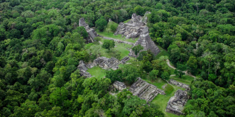
Тикаль – город цивилизации майя с величественными постройками.
Тикаль являлся центром культурного, географического и религиозного пространства Мира майя Гватемалы. Величие Тикаля было так велико, что достаточно посетить только один этот археологический комплекс, чтобы составить впечатление о жизни и мировоззрении древних майя Гватемалы.
Самые древние археологические находки комплекса Тикаль относятся к 9 в. до н.э. Расцвет города пришелся на 7-8 вв. н.э. В это время площадь Тикаля составляла 8 км2, а размер всей агломерации, включая сельскохозяйственные поля, достигал 120 км2.
Иероглифические надписи на стелах Тикаля датируют город с 292 г. до 889 г. н.э.
Тикаль старше Теночтитлана – столицы ацтеков в центральной мексиканской долине, и цитадели майя Чичен-Ица на полуострове Юкатан.
Население Тикаля в период расцвета было внушительным – от 70 до 100 тысяч человек.
Как стало возможным создать огромный и процветающий город в непроходимых джунглях вдали от источников пресной воды? Чудо Тикаля объясняется тем, что жители города создали искусную систему земледелия и отвода и сохранения воды.
Земледелие в Тикале основывалось на системе «приподнятых полей» – длинных и узких полосок земли в окружении каналов. Во время сезонных разливов рек обновлялся слой плодородной почвы, а лишняя вода отводилась по каналам. Таким образом, жители города решили сразу две задачи. Они не только собирали богатый урожай, но и с легкостью перевозили его по воде.
Кроме того, птицы, рыбы и моллюски, в обилии водившиеся в воде каналов, стали отличным источником белка, которого так не хватало в скудном рационе индейцев.
Похожая система каналов использовалась для сбора воды. По системе каналов дождевая вода собиралась в специальные цистерны. Археологи обнаружили в Тикале 3 такие цистерны.
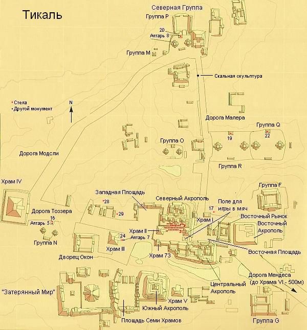
Постройки Тикаля располагаются на высоком фундаменте или на вершинах искусственных или естественных холмов – «акрополей». Скорее всего, строители Тикаля пошли на эту хитрость из-за влажности и частых разливов рек. По этой же самой причине архитектурные ансамбли соединялись между собой дорогами-дамбами.
Однако планировку построек в Тикале определяли не только ландшафт и природные условия, но и религия майя. Майя делили мир на Небеса, Землю и Подземное царство. Небеса и Подземное царство изображались в форме пирамид со смыкающимися основаниями. Таким образом Земля или Мир живых представлял собой прямоугольник. По бокам росли 4 дерева, на которых покоилось небо.
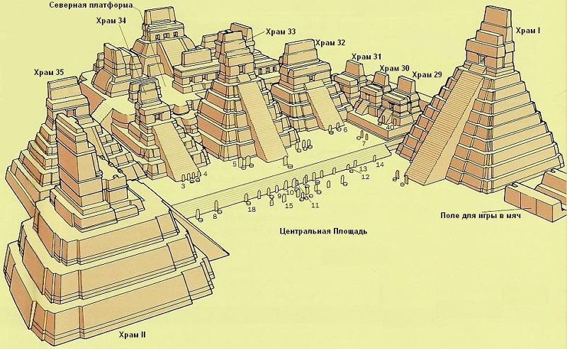
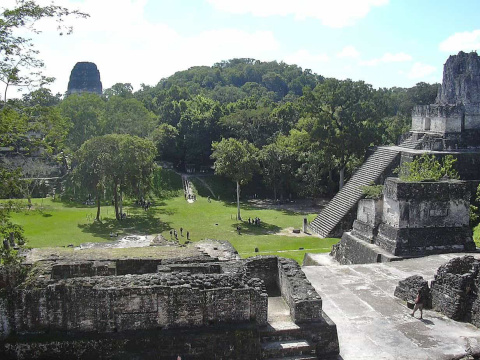
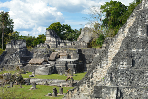
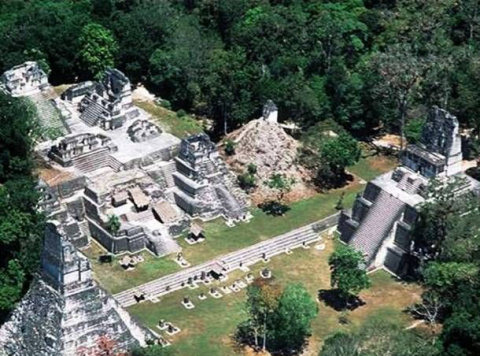
Комплексы Тикаля возведены в соответствии с космологией майя. Центром является прямоугольная площадь, по сторонам которой возвышаются пирамиды с храмами на вершинах.
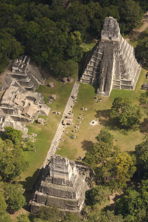
Главных площадей в Тикале 4 – Большая, Западная, Восточная и Площадь «семи храмов».
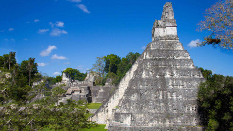
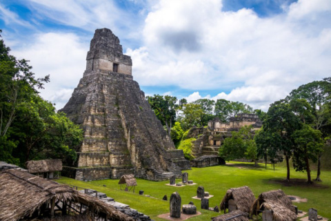
С западной и восточной стороны Большой площади величественно возвышаются пирамиды с Храмом гигантского ягуара 44 м и Храмом масок 38 м. Несмотря на относительно небольшую высоту по меркам архитектуры майя, выглядят пирамиды впечатляюще. Именно эти два храма можно увидеть на всех рекламных проспектах, посвященных турам в Гватемалу. Грани пирамид выглядят как практически отвесные, так как угол их наклона составляет 60 градусов. Только представьте, как сложно подняться на такую пирамиду, а тем более спуститься.
Храмы Большой площади Тикаля являлись усыпальницами правителей. Как показывают исследования, изначально высекались гробницы, а после над ними возводились пирамиды и храмы. Точно по такому же принципу была построена усыпальница Пакаля Великого в Паленке.
Храм Гигантского Ягуара служит усыпальницей легендарного правителя Тикаля Ах Какао, в соседнем с ним Храме масок покоится его супруга. Оба храма датируются 8 в. н.э.
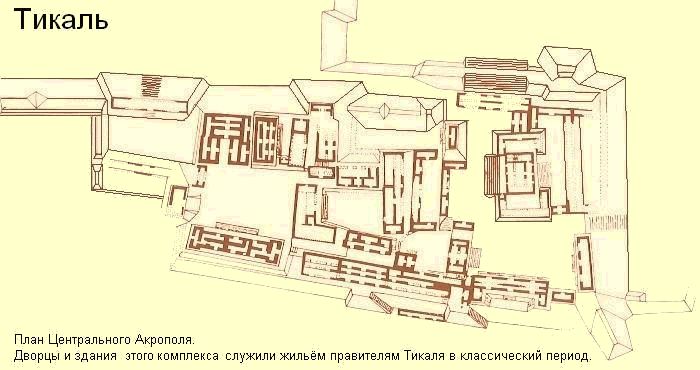
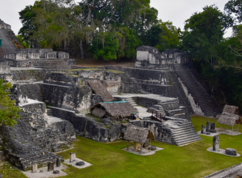
Космология майя размещала Мир Живых на юге. Поэтому архитекторы Тикаля возвели комплекс административных построек на юге Большой площади. Ученые назвали комплекс Центральный акрополь. Скорее всего, здесь размещался дворец правителя, жреческие комнаты и помещения для царской семьи и знати.
Самое известное строение Центрального акрополя – Дворец «Великого когтя ягуара». Строительство здания завершилось в 360 г. н.э.
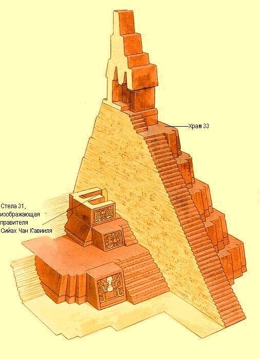
Северный акрополь Тикаля отличается от остальных построек города. Застройка этой территории велась в течение 11 веков, начиная с 3 в. н.э. В результате возник комплекс из 12 храмовых сооружений на единой платформе. На протяжении 500 лет Северный акрополь служил усыпальницей правителей города.
Археологи обнаружили в Тикале еще 7 храмово – административных комплексов. На карте эти объекты обозначаются латинскими буквами N, O, P, R и т.д. Комплексы построены по стандартной схеме – площадь в окружении пирамид, только в меньшем мастштабе. Все комплексы возводились с промежутками в 20 лет по окончании Катуна – периода в 20 лет в системе календаря майя.
Среди других сооружений археологического парка Тикаль выделяют комплексы «Затерянный мир», «Храм надписей» и «Храм двуглавого змея».
После заката цивилизации майя Тикаль поглотили джунгли. Древние руины обнаружили случайно, в 1848 г. во время сбора смолы чикле. Археологические исследования в Тикале начались несколькими десятилетиями позже.
Древнее название города до сих пор неизвестно. Ученые дали городу поэтическое название Тикаль, что означает «там, где слышны голоса духов». Предположительно, в древности город назывался «Холмы ягуаров».
С 2020 года древний центр майя Тикаль является частью Национального парка. Ежегодно парк Тикаль посещают с экскурсиями миллионы туристов.
Адрес: Parque Nacional Tikal
Тел: +502 2361 1399
Время работы:
06:00-18:00
Tikal is the city of the Mayan civilization with magnificent buildings.
Tikal was the center of the cultural, geographical and religious space of the Mayan World of Guatemala. The greatness of Tikal was so great that it was enough to visit this archaeological complex alone to get an impression of the life and worldview of the ancient Mayans of Guatemala.
The most ancient archaeological finds of the Tikal complex date back to the 9th century. BC. The city flourished in the 7th-8th centuries. AD At this time, the area of Tikal was 8 km2, and the size of the entire agglomeration, including agricultural fields, reached 120 km2.
The hieroglyphic inscriptions on the steles of Tikal date the city from 292 to 889 AD.
Tikal is older than Tenochtitlan, the capital of the Aztecs in the central Mexican valley, and the Mayan citadel of Chichen Itza on the Yucatan Peninsula.
The population of Tikal during its heyday was impressive – from 70 to 100 thousand people.
How did it become possible to create a huge and prosperous city in an impenetrable jungle far from fresh water sources? The miracle of Tikal is explained by the fact that the inhabitants of the city have created a skillful system of farming and water drainage and conservation.
Agriculture in Tikal was based on a system of “raised fields” – long and narrow strips of land surrounded by canals. During seasonal floods of rivers, the layer of fertile soil was renewed, and excess water was diverted through canals. Thus, the residents of the city solved two problems at once. They not only reaped a rich harvest, but also easily transported it by water.
In addition, the poultry, fish and shellfish found in abundance in the water of the canals became an excellent source of protein, which was so lacking in the meager diet of the Indians.
A similar canal system was used to collect water. Through a system of canals, rainwater was collected in special cisterns. Archaeologists have discovered 3 such cisterns in Tikal.
Tikal’s buildings are located on high foundations or on the tops of artificial or natural hills – “acropolis”. Most likely, the builders of Tikal went for this trick because of the humidity and frequent flooding of rivers. For the same reason, the architectural ensembles were connected by dam roads.
However, the layout of buildings in Tikal was determined not only by the landscape and natural conditions, but also by the Mayan religion. The Maya divided the world into Heaven, Earth and the Underworld. Heaven and the Underworld were depicted in the form of pyramids with closing bases. Thus, the Earth or the World of the Living was a rectangle. On the sides there were 4 trees on which the sky rested.
The Tikal complexes were built in accordance with Mayan cosmology. The center is a rectangular square, on the sides of which there are pyramids with temples on the tops.
The main squares in Tikal are 4 – Big, Western, Eastern, and Seven Temples Square.
On the western and eastern sides of the Great Square, the pyramids with the Temple of the Giant Jaguar 44 m and the Temple of Masks 38 m rise majestically. Despite the relatively low height by the standards of Mayan architecture, the pyramids look impressive. These two temples can be seen on all advertising brochures dedicated to tours to Guatemala. The faces of the pyramids look almost vertical, since the angle of their inclination is 60 degrees. Just imagine how difficult it is to climb such a pyramid, and even more so to descend.
The temples of the Great Square of Tikal were the tombs of the rulers. As studies show, tombs were initially carved, and then pyramids and temples were erected over them. The tomb of Pakal the Great in Palenque was built on exactly the same principle.
The Temple of the Giant Jaguar serves as the tomb of the legendary ruler Tikal Ah Cocoa, and his wife is buried in the adjacent Temple of Masks. Both temples date back to the 8th century. AD
Mayan cosmology placed the Living World in the south. Therefore, the architects of Tikal erected a complex of administrative buildings in the south of the Great Square. Scientists named the complex the Central Acropolis. Most likely, the palace of the ruler, priestly rooms and premises for the royal family and nobility were located here.
The most famous building of the Central Acropolis is the Great Jaguar Claw Palace. The construction of the building was completed in 360 AD.
The northern acropolis of Tikal is different from the rest of the city’s buildings. The construction of this territory was carried out over 11 centuries, starting from the 3rd century. AD As a result, a complex of 12 temple structures arose on a single platform. For 500 years, the Northern Acropolis served as the tomb of the city’s rulers.
Archaeologists have discovered 7 more temple-administrative complexes in Tikal. On the map, these objects are designated by the Latin letters N, O, P, R, etc. The complexes are built according to the standard scheme – an area surrounded by pyramids, only in a smaller scale. All complexes were erected at intervals of 20 years after the end of Katun – a period of 20 years in the Mayan calendar system.
Among other structures of the Tikal Archaeological Park, the complexes “The Lost World”, “Temple of Inscriptions” and “Temple of the Two-Headed Serpent” are distinguished.
After the fall of the Mayan civilization, Tikal was swallowed up by the jungle. The ancient ruins were discovered by accident in 1848 while collecting Chicle resin. Archaeological research in Tikal began several decades later.
The ancient name of the city is still unknown. Scientists gave the city the poetic name Tikal, which means “where the voices of the spirits are heard.” Presumably, in ancient times the city was called “Jaguar Hills”.
Since 2020, the ancient Mayan center of Tikal is part of the National Park. Millions of tourists visit Tikal Park every year.
© Times of Ukraine
Языковое наследие майя – http://news.timesofu.com/?p=8679
Библиотека интеллектуала:
«Иероглифические рукописи майя» – Ю.В. Кнорозов
http://shop.timesofu.com/?p=3427